Goudhurst – A walk through time
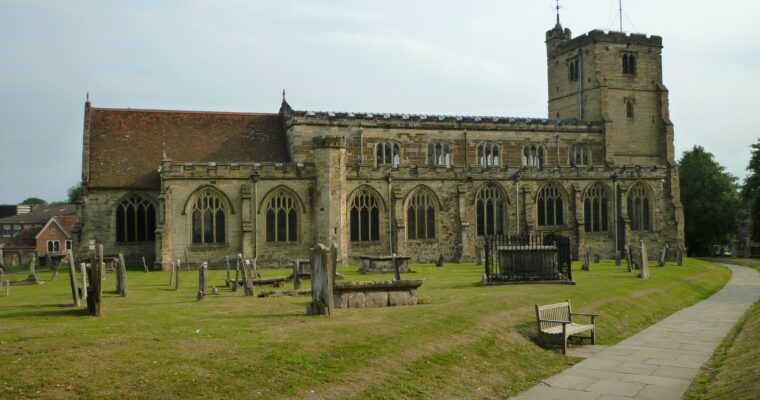
Originally a clearing in the forest that covered the south east, the village of Goudhurst established itself on high ground around St Mary’s Church. The building was dedicated in 1119, although it is likely that a church has occupied the site since Saxon times. Improvements were made over the next two centuries. In 1637, the church spire was struck by lightning and burnt down. Inside you’ll find some fine features – and walkers who recall Thomas Hardy’s Mellstock Quire can look for the singing gallery – built in 1769.
The village grew in prosperity in the 1330s, as Flemish weavers expanded from their base in Cranbrook to create the Kentish broadcloth industry. Their preference for drinking hopped beer, rather than the existing ale, led to the establishment of the Kentish hop industry, which shaped the agricultural landscape around the village, and provided a great many livelihoods in the area.
a.
Step by step guide
From the Weald Information Centre, head up the High Street towards Hartley, admiring the character buildings either side of the road as you go.
Pass Wheatfield Drive on the right hand side and turn into New Road, and follow the path to the road (A229). Cross the road into Angley Woods, following the HWLT, and ignoring other tracks. The path leads downhill and over a stream before rising, following a wide track. Follow the trail right, off the track and over a stream, bearing left up the hill to a surfaced track and past a woodshed on the left. Follow the track and bear left round the field edge leading to the Hartley to Iden Green road (B2085).
Cross the road and follow the field edge past Glassenbury House on the right.
Follow the path on the edge of the fields, through a gate and onto a driveway passing houses and following waymarkers out to the open fields again. Turn left at the marker, then right, staying on the track leading past the duck ponds and ancient field boundaries, noting the magnificent ancient oak and historic hornbeam field banks as you go.
Follow the path past Smugley Farm on the left – a property that was involved in smuggling, as its name suggests. An underground passage was reputed to run from it to Triggs Farm, just below Goudhurst, and to the right of the path.
Continue across a field and over a bridge, then up towards Goudhurst, keeping to the right of the field. Walk along a track with houses on your left, go over a stile into a field which leads into a disused ménage. Come back onto the track and carry on until you reach a lane. Turn right and go up the lane until you reach Tiddymotts Lane, then double back on yourself until you see the path on the right, leading up to the church.
Walk through the churchyard and out onto Back Lane, opposite the weavers' cottages .
Walk along the pavement next to the main road towards Cranbrook, turn left down Tattlebury Lane, and bear left down a lane with a no-entry sign at the top. Cross the road and walk down Ladham Road opposite, sign posted to Curtisden Green. Take the footpath down the driveway to Ladham House, taking in the wonderful views towards Horsmonden on your left.
Continue down the drive past Ladham house and look for a stile on the right, leading into on old orchard. Head for the right-hand side of the houses and you will reach a lane, going straight over into a driveway. The footpath drops away to the left of a hedge opposite the house and leads into young woodland. Follow the path between the wood edge and hedge as it leads into woodland, then over a stream. Walk up round the perimeter of a garden until you reach a road. Go straight over the road, down the right side of a field and orchard, past a house on the left, and continue up into Old Park Wood. Follow the path up through the wood and onto a track that leads to a cottage in the woods. If you are in need of refreshment, follow the track up to the road and the Peacock Inn is just over the other side. You will need to retrace your steps to return to the walk.
Otherwise, turn left past the cottage and follow the footpath through chestnut coppice and a pine plantation until you reach a road. Notice the information panel about the wildlife of the wood just before you reach the gate onto the road.
Turn left and walk down the lane, an old drove road, towards Collier's Green School. Turn right, go over a stile below the school and walk along the bottom of the school grounds to reach another lane. Cross over to the footpath opposite, go through the hedge and follow it through a field, into a wood, eventually emerging into a field. Head for the gap between the lakes in front of you and walk up the slope, through the gap in the hedge, and into a field. Follow the field boundary towards the cottages at Hazelden Farm.
Turn right and walk down the driveway to the road. Cross the road and go down the drive towards the house (Thie Cheery). Turn left at a gap in the hedge and follow the enclosed footpath until you reach the road (A262). Cross straight over the road and follow the track down towards a stream and bridge, leading up though the wood. Note the pits that remain from quarrying in Gravel Pit Wood. Carry straight on, eventually leaving the wood with paddocks on your right and a fence on the left. You will then reach a driveway that leads onto the road (A229). Cross to the footpath opposite, go through a gate and up through a field onto a path between playing fields on the left, and Cranbrook Primary school on the right. At the end of the path, bear left through a gate and continue into the churchyard and so back to the place where you started the walk.


